2017 September Arctic sea ice forecasts using July data
This blog post follows on from the last three blog posts (scroll down!).
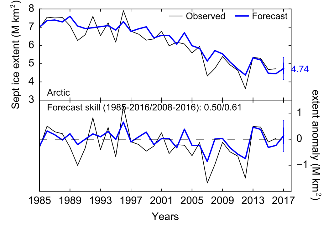
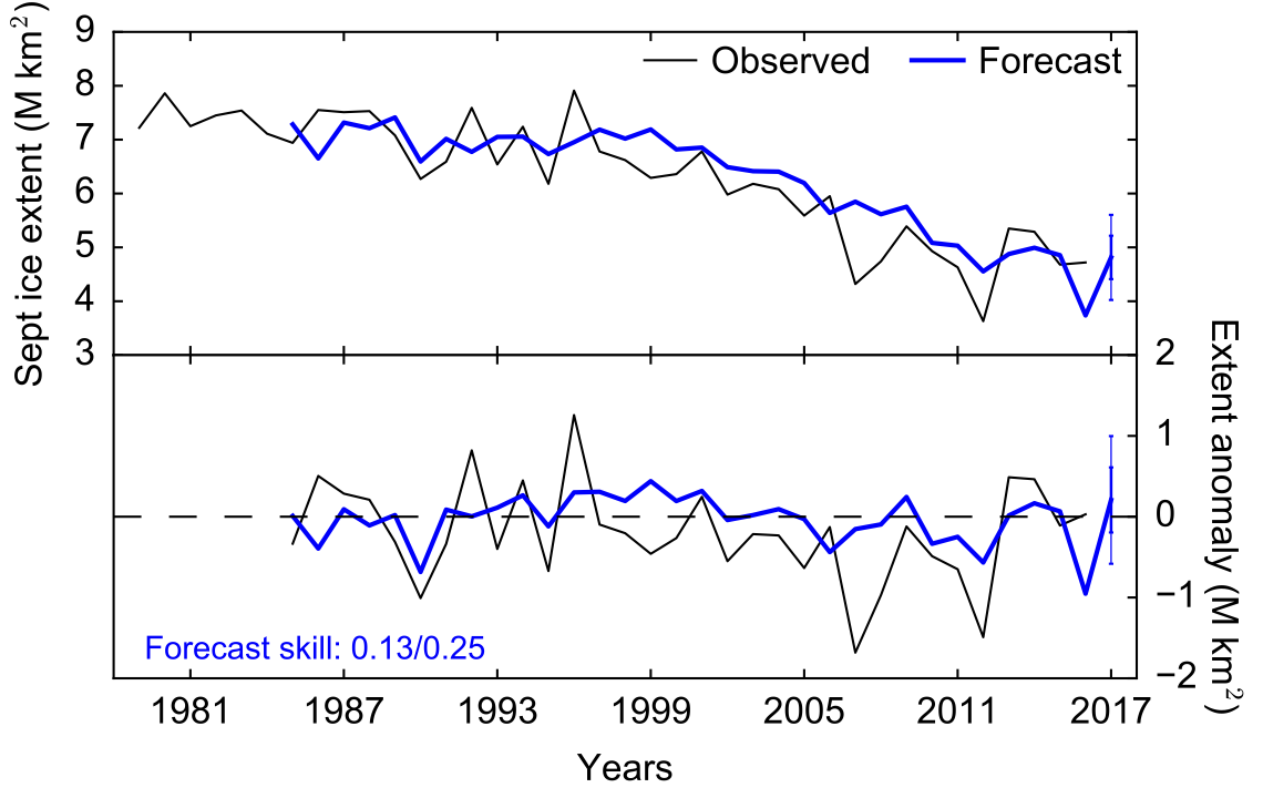
I've now run updated forecasts of September Arctic sea ice extent using the July sea ice concentration data, which is producing an extent of 4.74 M km2, a bit higher than the June forecast (4.50), but still not low enough to suggest a record low.
This is the third forecast I will submit to the Sea Ice Prediciton Network's Sea Ice Outlook.
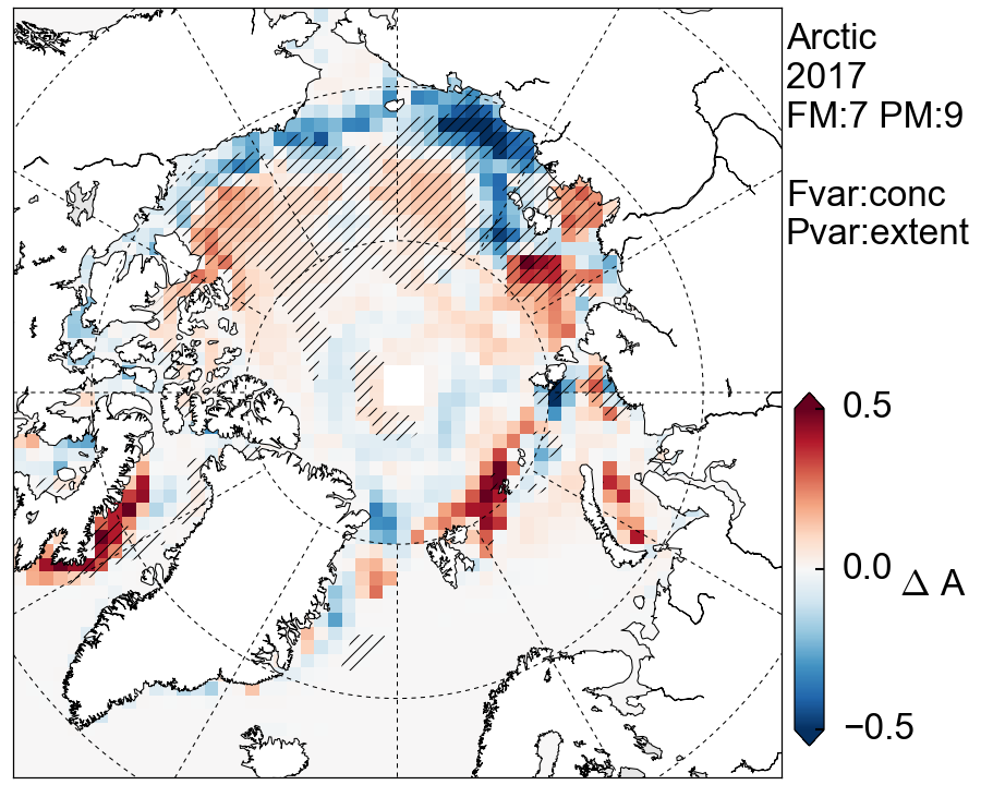
Looking briefly at the drivers of the forecast, Fig. 2 shows the concentration anomalies (relative to the long-term linear trend). We can see the low 2017 forecast is mainly driven by a mix of positive and negative anomalies in the Beaufort Sea (a typically important area for September sea ice forecasts), negative anomalies in the East Siberian sea and positive anomalies in the Laptev and Barents Seas.
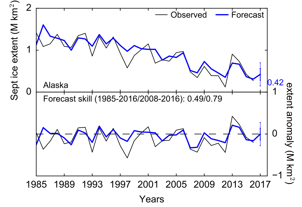
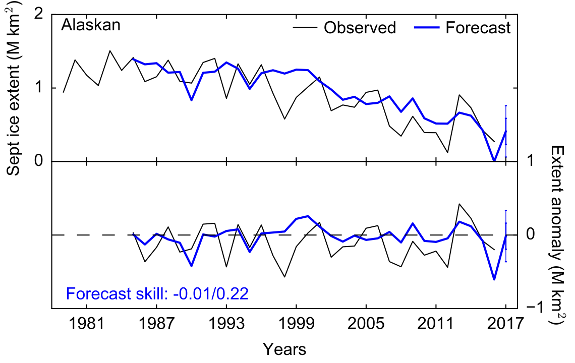
As discussed in earlier posts, our model can also be used to produce skillful regional sea ice forecasts, specifically the ice extent in the Alaskan Arctic region, which includes the Beaufort and Chukchi seas. Our July forecast of Alaskan sea ice extent is coming in at 0.42 M km2, very similar to the May forecast (0.41). It looks increasingly likely that we won't be seeing a record low Alaskan sea ice extent, although the extremely early ice retreat in the Chukchi sea could make things interesting. We've never seen such an early ice retreat in that region, so our model might struggle to properly account for this.
As discussed in the last blog post, the SIO is also soliciting Antarctic sea ice forecasts.
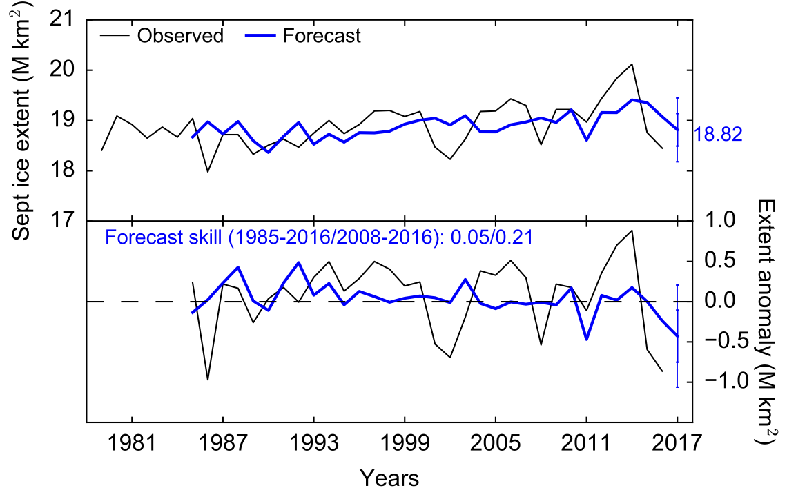
Our July forecast shows some skill, especially in recent years, with the forecast producing an extent of 18.82 M km2, below the extent suggested from the long-term trend, and similar to the June forecast.
2017 September Arctic sea ice forecasts using June data
This blog post follows on from the last two blog posts (scroll down!).
June is an especially important month for summer sea ice forecasts, as the ice starts to show clear signs of melt and the forecast skill improves significantly. I've now run updated forecasts of September Arctic sea ice extent using the June sea ice concentration data, producing a forecast of 4.50 M km2, a bit lower than the May forecast (4.80), but still not low enough to sugegst a record low.
This is the second forecast I will submit to the Sea Ice Prediciton Network's Sea Ice Outlook.
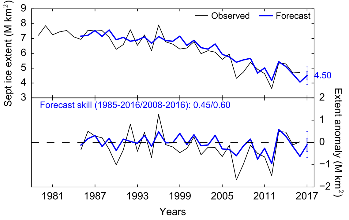
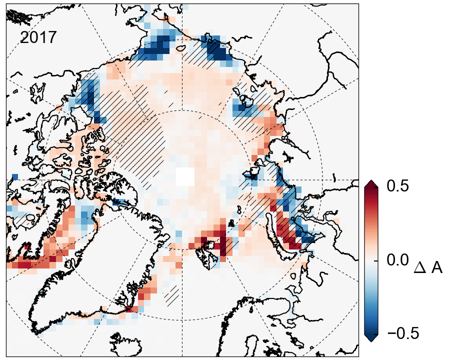
Looking briefly at the drivers of the forecast, Fig. 2 shows the concentration anomalies (relative to the long-term linear trend). We can see the low 2017 forecast is driven by negative anomalies in the Beaufort Sea (a typically important area for September sea ice forecasts) and also the Laptev Sea. The negaivte/positive anomalies in the Kara Sea appear to be broadly cancelling each other out. Some of the positive anomalies (e.g. in the Baffin Bay west of Greenland) don't count towards the forecast as they show no historical correlation with Septmeber sea ice, and are thus excluded by the weighting scheme.
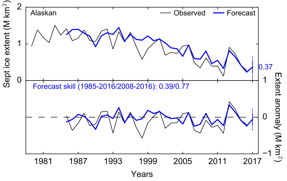
As discussed below, our model can also be used to produce skillful regional sea ice forecasts, specifically the ice extent in the Alaskan Arctic region, which includes the Beaufort and Chukchi seas. Our June forecast of Alaskan sea ice extent is coming in at 0.37 M km2, just slightly lower than the May forecast (0.41). It looks like 2017 could be close to the record low extent set in 2012, with even a small chance of an ice-free Alaskan Arctic.
The SIO is also soliciting Antarctic sea ice forecasts. For simplicity, they are asking for the same forecast time period (i.e. spring forecasts of September Antarctic sea ice). With it being the other hemisphere, September is close to the winter maximum Antarctic sea ice extent, so it's a pretty different thing we're forecasting here. The geometry of the poles are also opposite, with Antarctic sea ice surrounding the land, instead of land surrounding the sea ice, as it is in the Arctic. The potential skill of Antarctic sea ice forecasting is still an open field of research (which hasn't been explored much to-date).
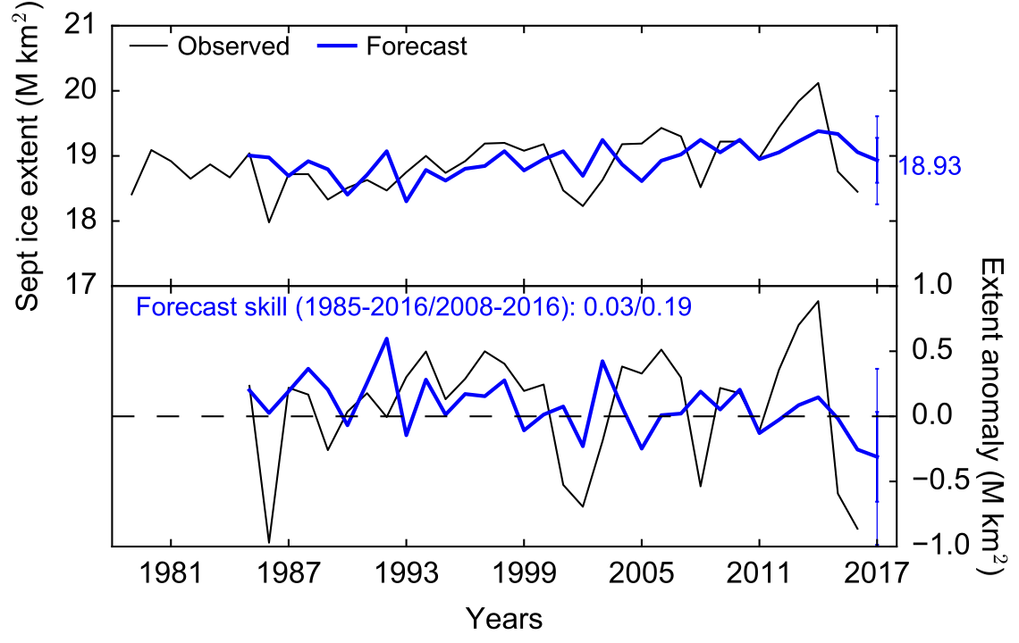
The forecast shows some skill, especially in recent years, with our forecasting giving an extent of 18.93 M km2, below the extent suggested from the long-term trend. Note that the Antarctic September trend is slightly positive, as opposed to the strongly negative trend in the Arctic.
2017 September Arctic sea ice forecasts using May data
This blog post follows on from the one I published last month (scroll down!). I've now run updated forecasts of September Arctic sea ice extent using the May sea ice concentration data, producing a forecast of 4.81 M km2, very similar to the April forecast.
This will be the first forecast I submit to the Sea Ice Prediciton Network's Sea Ice Outlook.
As discussed in our paper in Earth's Future, our model can also be used to produce skillful regional sea ice forecasts, specifically the sea ice extent in the Alaskan Arctic region, which includes the Beaufort and Chukchi seas. Like the pan-Arctic forecasts, the Alaskan forecasts become a lot more reliable when we have the June data and the eastern Beaufort Sea starts to open up more fully, but there is some skill back in May when judged over recent years. See Fig 2 below. Our May forecast of Alaskan sea ice extent is coming in at 0.41 M km2, so similar to what we observed last year. Note how in 2016 the May forecast was of an ice-free Alaskan region (which didn't happen), highlighting the continued challenges with forecasting at this earlier lead time.
I'll be producing a more-in depth analysis of the June forecasts when we get them, so watch this space.
2017 September Arctic sea ice forecasts using April data
A few months ago I published a paper in Earth's Future with several colleagues from NASA Goddard and the UK, where we demonstrated 'skillful' seasonal forecasts of summer (September) Arctic sea ice extent. We define 'skillful' as a forecast that performs better than simply continuing the linear, downward, trend in Arctic sea ice extent.
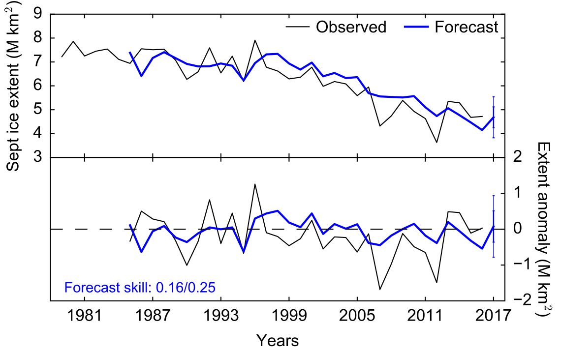
Our skillful seasonal forecasts use satellite data regarding the coverage and melt onset of sea ice across the Arctic. The forecasts can be generated from as early as March, but get more skillful/reliable as the melt season progresses through spring and into summer. In general, the forecasts in June onwards are noticably better, so earlier forecasts (like the ones presented in this blog post) should be regarded with caution! My plan is to update this blog series each month as new data comes in, and our forecasts improve.
For now, I'm just using satellite derived sea ice concentration data in April to drive my September Arctic sea ice forecast. See Figure 1 for the forecast.
The 2017 forecast suggests a September Arctic sea ice extent similar to 2016 - also similar to the extent expected from a continuation of the long-term downward trend, with a low likelihood of a new record low (less than the record set in 2012). Again, the early forecasts have historically struggled to forecast extremes. They do a pretty good job of caturing the ups and downs in ice extent over and above the long term decline (the bottom panel expresses the observations and forecast in terms of the linear trend anomaly).
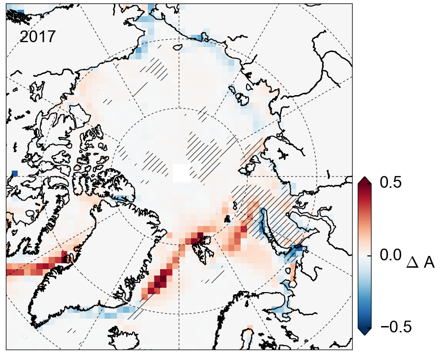
In Figure 2 we show the regional drivers of this specific 2017 forecast. The red regions indiciate more sea ice than expected from the long-term trend in each grid cell, while blue regions indicate less. The hatched regions highlight regions that historically correlate with September sea ice at this forecast lead time (forecast month). Regions of no historical correlation are not included (we explored this more in the paper, so read that for more information).
This means the strong reds either side of Greenland that indicate higher than expected ice concentration, especially in the southern Baffin Bay, aren't being included in this forecast as we found no historical correlation of the ice in these areas with September sea ice extent (those regions become ice free in summer anyway). The 2017 forecast is thus mainly driven by the small regions of higher than expected and lower than expected coverage around the Kara Sea (north of Scandinavia). The fact our forecast is being driven by these very localized regional changes isn't ideal obviously, hence why things get more interesting as the melt season progresses and we observe bigger/vaster sea ice anomalies.
In summary: our early forecast of September Arctic sea ice suggests an ice extent similar to last year and no record low. This forecast isn't hugely reliable, so check back in June and July especially for the more reliable forecasts I will be posting. I'll try and include some other datasets and produce some regional forecasts too.
Alek